Wilsons Promontory Southern Circuit Adventure
TAKE A
HIKE
AND
GET LOST
IN THE
RIGHT
DIRECTION
By James McLaren.
Wilsons Promontory – or the Prom as it is affectionately known – is the southernmost tip of the Australian mainland. It is located in South East Gippsland. The Prom has something for everyone, from secluded rainforest walks to diverse plant communities and pristine coastlines. Check out a map from Parks Victoria here.
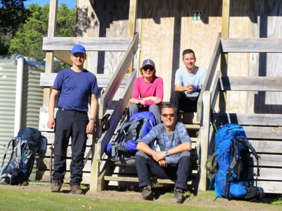
Day 1: Getting to Wilsons Promontory from Adelaide
Our drive from Adelaide to Wilsons Promontory was a direct but solid 12 hours. The Tidal River Visitor Centre is a further 30 minutes drive from the Wilsons Promontory National Park entrance. Once in the park, we drove slowly to avoid the teeming wildlife who get out and about between dusk and dawn.
We pre-booked our campsites as overnight hiking permits through www.parks.vic.gov.au/stay, knowing the visitor centre would be closed when we arrived.
Having carefully planned our multi-day hike, we kept a keen eye on the weather radar. Not only was the walk going to be a challenge of fitness and stamina, but it was also going to be incredibly cold and more than likely raining! Thankfully, after leaving a massive rain front in SA, we entered a gap in the weather. Our plan was to pack as much as possible into each day and by adding some walking sections together.
Day 2
- High of 13℃, overnight low of -2℃
- Total distance walked: 20.23km
- Ascent: 1505m Descent: 1473m
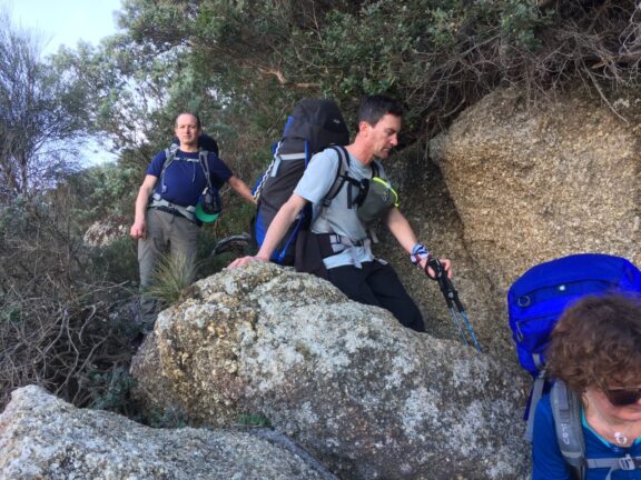
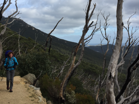
After packing and checking our gear, we started our walk from the Tidal River campgrounds. We instantly warmed up by walking the steep winding road to Telegraph Saddle Carpark. Four kilometres later, the carpark graced us with sweeping panoramic views of the National Park, Mt Oberon, Mt Ramsay and Mt McAlister, giving us an idea of how big the Prom actually is. This is when we knew our adventure was about to get real!
The trail throughout the Prom is very well maintained and signposted, and distances are accurate. Don’t underestimate the timings though, as some sections are incredibly steep. The word ‘relentless’ is an understatement. The Australian Walking Track Grading system rates the southern hikes at Level 4 based on the most difficult sections.
Enchanting landscapes at the Prom
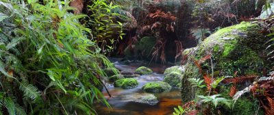
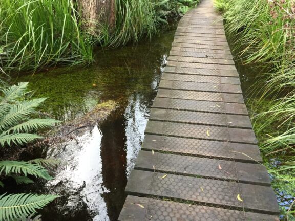
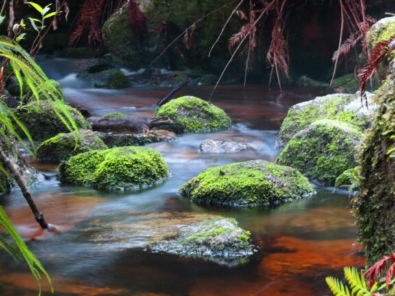
Walking from the Saddle down to Sealers Cove was around 10.5kms. You actually feel like you could be anywhere in Australia. The ecosystems are going crazy! The rainforest is enchanting, massive ferns dominate the sides of the track, mushrooms stand proud, and many small streams add to the enjoyment of a very up-and-down muddy trail.
In 2011, sections of the boardwalk through Sealers Swap & Blackfish Creek were damaged by flood waters and fallen trees. The boardwalk is now raised to mitigate any future flood events. This section of the forest walk has an eerie feeling about it … a great location for a scary film perhaps.
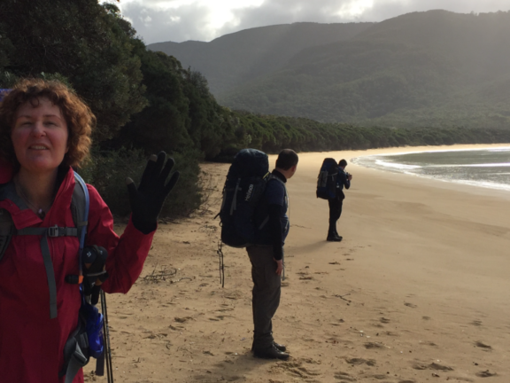
Anyway, just before arriving at Sealers Cove we walked out of the rainforest and onto a pristine, golden-sanded beach. This section is refreshing with sounds of the ocean and magnificent panoramic views of the coastline. We had perfect tide times and were able to avoid a deep water crossing (it only came up to our knees). We made the unanimous decision to have our late lunch on the beach and rest up for a while.
Pressing on to Refuge Cove
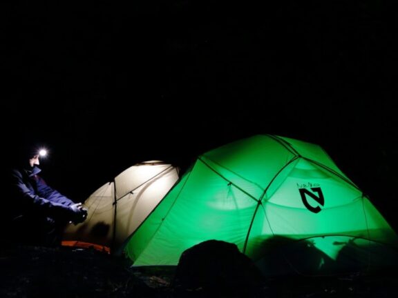
Sealers Cove Campsite is approximately 700m from the beach. It’s really well laid out. The water source comes from a flowing creek via a plastic hose and you must be prepared to treat water so it is fit for drinking. Already carrying sufficient water, we pressed on another 7.1kms to Refuge Cove campsite. We arrived by head torch about 30 mins after dark. Feeling relieved to take our packs off, we set about claiming our camp spots and getting our evening meals sorted. I must say, this was one of those times when a dehydrated meal never tasted so good!
A quest for water and some night visitors
Before settling in for a well-earned sleep, we realised we needed water. The obligatory short night walk quest commenced. Shortly before finding our water source and filtering out the tannins, we saw a magnificent owl. It swooped down from a hidden spot claiming his evening meal. After making our way back to camp, another member of the spooky forest family greeted us – a big black possum. The possum had a fascination with our location and proceeded to remind us that we were his guests. Having made sure that we had stored all food securely and packed away all rubbish (including food scraps), we all called in an early night … apart from Darren, who had the pleasure of dealing with the possum for a few more hours.
Day 3
- High of 13℃, overnight low of -2℃
- Total distance walked: 21.53km
- Ascent: 1690m Descent: 1528m
The day started with a glorious sunrise and a birdlife singing a morning chorus. With breakfast out the way, we slowly packed up under supervision from a couple of superb fairy-wrens putting on quite a show.
Today’s challenge was to venture onto Roaring Meg Campsite via Kersops Peak, Little Waterloo Bay, and Wilsons Promontory Lightstation. This was the day of some serious ups and downs. Not only were sections of this walk quite ruthless, but the chop and change of the colder shade to sun exposure was forever a challenge. For most of the morning I was walking in two lightweight layers of merino wool and my rain jacket to protect me from the chilly air.
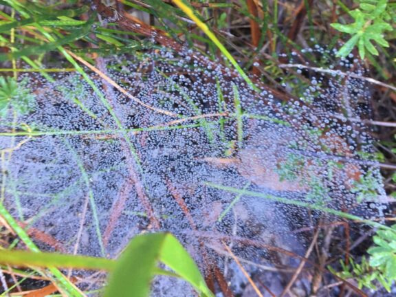
The morning gave us some stunning highlights: frosted footprints on a breathtaking deserted beach, frozen spiders webs gleaming bright silver, and an amazing display of different types of mushrooms scattered throughout the forest.
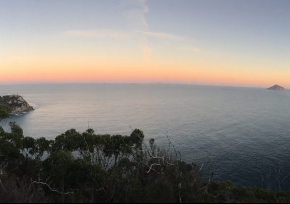
We were blessed with clear skies as the afternoon’s walking challenge unfolded. We saw many elevated views of the sweeping headlands and cheeky glimpses of the gorgeous coastlines that could rival anywhere in Europe. You could only get to our location by overnight walking, sailing or by helicopter! How lucky or crazy are we!
Wilsons Promontory walking environments
The entire day’s walking environments were completely varied. One moment we were walking in lush rainforests with occasional boardwalks, the next, we tackled steep rocky steps, then scrabbled down rocks onto beautiful beaches with small inlet crossings. The sand was golden silver and the ocean was so clear with a colour variation you could only find in a paint shop. Thank you Mother Nature!
So, time was ticking and we were all very tired yet elevated. This afternoon’s challenge had deserved more breaks than the previous day. Not wanting to arrive at camp after dark, we pressed on with each of us taking the lead to encourage a steady group pace.
Decision time
Before long, decision time came. Should we make an extra side trip or not? The team split. Stuart was adamant that the lighthouse must be viewed and decided to leave his pack under the watchful eye of the local currawong! He saw the lighthouse views, took a private tour of the lighthouse, and witnessed a whale breaching the water off the coast. Then Stuart returned to find the contents of his pack lid spilled open and his precious lollies and an evening meal stolen! Obviously the cheeky currawong had the same tastes as Stuart.
Roaring Meg
Mel, Darren and I arrived at Roaring Meg campsite (again by head torch light) about an hour and a half before Stuart. We very quickly ditched our packs and set up tents as we needed to keep ourselves warm! Fires, including campfires and solid fuel barbeques, are not permitted in Wilsons Promontory National Park at any time.
Roaring Meg has two campsites. One is down low in the dampest, coldest valley next to the flowing creek (ie Roaring Meg), and the other is elevated and exposed on top of a steep track. We only found the second campsite after we had set up at the first, and decided that it would be too much effort to relocate. It was the coldest night in the region for many years. In hindsight, we all agreed that camping in the lowest, dampest point by the creek with no airflow was not the best decision. This was confirmed by Stuart upon his much later arrival.
With dinner out the way, we topped up on our water supplies and called it a night. Reflecting back, I think this was the coldest time I’ve experienced, not just due to the weather, but also the amount of energy burnt during the day’s challenge.
Day 4
- High of 14℃, overnight low of -2℃
- Total distance walked: 16.98km
- Ascent: 436m Descent: 611m
Somewhat rested and refreshed, we woke early to the sound of Roaring Meg. It didn’t take long for all of us to realise how beautiful this freezing cold campsite was. Amongst the mossy rocks and lush ferns was an amazing creek ecosystem that only daylight had revealed.
Not wanting to hang around longer than needed, we decided to half pack up and have our breakfast at the elevated campsite, which had low platform tables and a toilet. Coffee was on everyone’s mind!
As we set about making breakfast, it didn’t take us long to realise that Stuart’s currawong friend was lurking around. As we tended to a gas bottle that had frozen itself to the table, the fearless currawong helped himself to a couple of Mel’s muesli bars. This was a reminder for us to never feed or leave food where it is accessible to wildlife.
After securing our damp tents, food and rubbish, we were now ready for the day’s final leg and adventures.
Mother Nature’s Break at Wilsons Promontory
Today’s challenge was to reach Tidal River campsite by mid-afternoon via Martins Hill, the Halfway Hut, Telegraph Junction and Oberon Bay. Mother Nature decided to give us a break today, providing us with incredible ocean views, far more forgiving walking trails, and some sunshine in the afternoon.
The day comprised of three amazing beach walks and quite a few water crossings. The trail was much more descending than ascending.
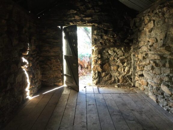
Halfway Hut
Halfway Hut was a very rewarding discovery. Camping in the hut is frowned upon, but it would be a great refuge in seriously bad weather. The Oregon timber suggests Defence Forces of WW2 vintage, considering the Prom’s wartime use.
Being our last walking day we all had an uplifted sense of achievement and camaraderie – with the obligatory aches and pains. Many times our conversation turned hot showers and counter meals. Somehow this gave us all a renewed energy!
Plundering
We reached Tidal River campsite in good time and set about plundering the car for all those things we had gone without. Next we pitched our wet tents, patted the local wombats, and enjoyed that well-needed hot shower in readiness for the pub meal we dreamt about.
However, not all went to plan for Stuart. After pitching his tent and making it as comfortable as possible, he neglected to zip it up and had a very unexpected visitor whilst he was checking the car for any final bits of kit. Returning to his tent, Stuart watched a rather large wombat waddle off after exiting the tent door. To Stuart’s surprise and dismay, one of the local friendly wombats had decided to mark its territory all over the inside of his tent! Needless to say this was incredibly unfortunate for Stuart – but incredibly funny to all of us!
Completing our evening feast, we all concurred that we needed another early night, as we had an early pack up and departure.
Day 5: Homeward bound
We rose at 4am ready for the 12 hour return drive. One thing about this hour of the morning is how sound travels: we all had to be very mindful of the other campers in our near vicinity. I must admit, packing up a frozen tent (which was still frozen when I arrived home!) and scraping ice off the wind screen while keeping quiet certainly tested me! I decided to speed up this process and bundle things together, stuffing them in the tray of my ute.
We knew the weather was on the turn. As the rain bore down relentlessly, we all realised our luck throughout the adventure. Driving out of the National Park was a slow process. Kangaroos dotted the long windy road and by the time we approached Melbourne we reached peak hour traffic.
The trip back to Adelaide seemed to go on forever, but at least we all had a share of driving. We returned to a huge weather front which presented us with difficult driving conditions in the rain.
A successful hike
It was quite funny to observe how we were all walking with our new aches! The ups and downs had taken their toll, but the sense of achievement far outweighed our pains. It’s amazing how much hiking is about mental ability over physical ability. For most trails and most people, if you have the tenacity to keep going, you will get through the hike in one piece. It may take a long time and require a lot of breaks, but that’s not how a hike is judged. A successful hike means getting outside and into nature, whether it’s for a half-kilometre, a half an hour, or several days. You choose your goal and define what it means to meet that goal. We seriously met and conquered our walking challenge.
Some points to consider when hiking the Southern Circuit, Wilsons Promontory
- Wear sturdy walking boots and be equipped for all weather conditions.
- Know basic first aid and carry a first aid kit.
- Expect walk completion times to vary significantly depending on weather, fitness and experience.
- Check tide times to avoid deep water crossings at creeks at Sealers Cove and Oberon Bay.
- Carry sufficient drinking water and know how to treat water. The MSR Hyperflow Microfilter is an efficient option for groups. Untreated creek or tank water may be available at some campsites, but supply is not guaranteed.
- Leave no trace – store all food securely and carry out all rubbish, including food scraps.
- Stay on walking trails to avoid getting lost or spreading Cinnamon Fungus. This waterborne disease kills flora and can be carried to new areas on the soles of your shoes.
- All plants, animals, other natural features and cultural sites are protected and must not be disturbed or removed.
- Do not feed the wildlife; you are the guest in their environment.